India States and Union Territories Comprehensive Dataset
This dataset provides detailed information on all 36 states and union territories of India, including their names in English and Hindi, capitals, type, region, ISO codes, population, area, and official languages.
Free Download
Key Takeaways
- Access up-to-date details on all 36 Indian states and union territories.
- Explore key demographic and geographical data like population, area, and official languages.
- Download complete information on capitals, regions, and ISO codes for each administrative division.
- Leverage structured data for educational, research, or development projects.
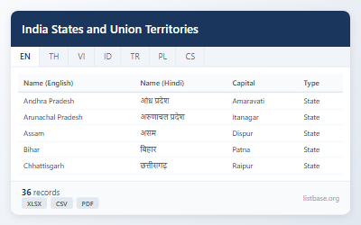
Showing 36 of 36
| Name (English) | Name (Hindi) | Capital | Type | Region | ISO Code | Population | Area (km²) | Official Languages |
|---|---|---|---|---|---|---|---|---|
| Andhra Pradesh | आंध्र प्रदेश | Amaravati | State | South India | IN-AP | 49577103 | 162975 | Telugu |
| Arunachal Pradesh | अरुणाचल प्रदेश | Itanagar | State | Northeast India | IN-AR | 1383727 | 83743 | English, Hindi |
| Assam | असम | Dispur | State | Northeast India | IN-AS | 31205576 | 78438 | Assamese |
| Bihar | बिहार | Patna | State | East India | IN-BR | 104099452 | 94163 | Hindi |
| Chhattisgarh | छत्तीसगढ़ | Raipur | State | Central India | IN-CT | 25545198 | 135192 | Hindi, Chhattisgarhi |
| Goa | गोवा | Panaji | State | West India | IN-GA | 1458545 | 3702 | Konkani |
| Gujarat | गुजरात | Gandhinagar | State | West India | IN-GJ | 60439692 | 196024 | Gujarati |
| Haryana | हरियाणा | Chandigarh | State | North India | IN-HR | 25351462 | 44212 | Hindi |
| Himachal Pradesh | हिमाचल प्रदेश | Shimla | State | North India | IN-HP | 6864602 | 55673 | Hindi |
| Jharkhand | झारखंड | Ranchi | State | East India | IN-JH | 32988134 | 79716 | Hindi |
| Karnataka | कर्नाटक | Bengaluru | State | South India | IN-KA | 61095297 | 191791 | Kannada |
| Kerala | केरल | Thiruvananthapuram | State | South India | IN-KL | 33406061 | 38852 | Malayalam |
| Madhya Pradesh | मध्य प्रदेश | Bhopal | State | Central India | IN-MP | 72626809 | 308252 | Hindi |
| Maharashtra | महाराष्ट्र | Mumbai | State | West India | IN-MH | 112374333 | 307713 | Marathi |
| Manipur | मणिपुर | Imphal | State | Northeast India | IN-MN | 2855794 | 22327 | Meitei |
| Meghalaya | मेघालय | Shillong | State | Northeast India | IN-ML | 2966889 | 22429 | English, Khasi |
| Mizoram | मिज़ोरम | Aizawl | State | Northeast India | IN-MZ | 1097206 | 21081 | Mizo, English |
| Nagaland | नागालैंड | Kohima | State | Northeast India | IN-NL | 1978502 | 16579 | English |
| Odisha | ओडिशा | Bhubaneswar | State | East India | IN-OR | 41974218 | 155707 | Odia |
| Punjab | पंजाब | Chandigarh | State | North India | IN-PB | 27743338 | 50362 | Punjabi |
| Rajasthan | राजस्थान | Jaipur | State | North India | IN-RJ | 68548437 | 342239 | Hindi |
| Sikkim | सिक्किम | Gangtok | State | Northeast India | IN-SK | 610577 | 7096 | English, Nepali |
| Tamil Nadu | तमिलनाडु | Chennai | State | South India | IN-TN | 72147030 | 130060 | Tamil |
| Telangana | तेलंगाना | Hyderabad | State | South India | IN-TG | 35003674 | 112077 | Telugu, Urdu |
| Tripura | त्रिपुरा | Agartala | State | Northeast India | IN-TR | 3673917 | 10486 | Bengali, Kokborok |
| Uttar Pradesh | उत्तर प्रदेश | Lucknow | State | North India | IN-UP | 199812341 | 240928 | Hindi |
| Uttarakhand | उत्तराखंड | Dehradun | State | North India | IN-UT | 10086292 | 53483 | Hindi |
| West Bengal | पश्चिम बंगाल | Kolkata | State | East India | IN-WB | 91276115 | 88752 | Bengali |
| Andaman and Nicobar Islands | अंडमान और निकोबार द्वीपसमूह | Port Blair | Union Territory | Islands | IN-AN | 380581 | 8249 | Hindi, English |
| Chandigarh | चंडीगढ़ | Chandigarh | Union Territory | North India | IN-CH | 1055450 | 114 | Hindi, Punjabi |
| Dadra and Nagar Haveli and Daman and Diu | दादरा और नगर हवेली और दमन और दीव | Daman | Union Territory | West India | IN-DH | 585764 | 603 | Gujarati, Hindi |
| Delhi | दिल्ली | New Delhi | Union Territory | North India | IN-DL | 16787941 | 1484 | Hindi, English |
| Jammu and Kashmir | जम्मू और कश्मीर | Srinagar (S), Jammu (W) | Union Territory | North India | IN-JK | 12267032 | 42241 | Urdu, Hindi |
| Ladakh | लद्दाख | Leh | Union Territory | North India | IN-LA | 274000 | 59146 | Ladakhi, Hindi |
| Lakshadweep | लक्षद्वीप | Kavaratti | Union Territory | Islands | IN-LD | 64473 | 32 | Malayalam |
| Puducherry | पुडुचेरी | Puducherry | Union Territory | South India | IN-PY | 1247953 | 479 | Tamil, French |
Use Cases
- Import the CSV file into your SQL database or Python scripts to power geographical data analysis and application development.
- Use the Excel file to create Pivot Tables, filter data by region, or perform VLOOKUP for quick analytical reports on Indian administrative divisions.
- Print the PDF version for classroom reference, educational presentations, or offline geographic studies of India's states and UTs.
- Analyze population and area data for comparative studies on regional development and urban planning across India.